 English
Views: 55 Author: Site Editor Publish Time: 2022-11-22 Origin: Site


The Drawing Method of Geophysical Exploration Line Section
First, draw the coordinate line on the drawing. The vertical coordinate is based on the elevation of the geological output, and the horizontal line is drawn according to a certain height difference. The coordinate line with the shortest intercept with the hatching line is marked on the graph (Figure. A).
The drawing of the geological boundary of the surface topography. use the coordinate line as the baseline to draw the topographic conversion points and geological boundary points on the section, and then use a slur to connect these topographic points to obtain a topographic line, and the geological boundary is extended according to the occurrence. ( Figure A)

(Figure. A)
The drawing of geophysical exploration engineering. Take the coordinate line as the baseline, and draw the positions of exploration trenches, shallow wells and boreholes on the sectional view according to the measurement results. (Figure B)

(Figure B)
The drawing of geological boundaries; according to the original catalogue data of various geophysical exploration projects, various geological boundary points are scaled down to the corresponding positions, and their occurrence, sampling location and number are indicated. (Figure C)
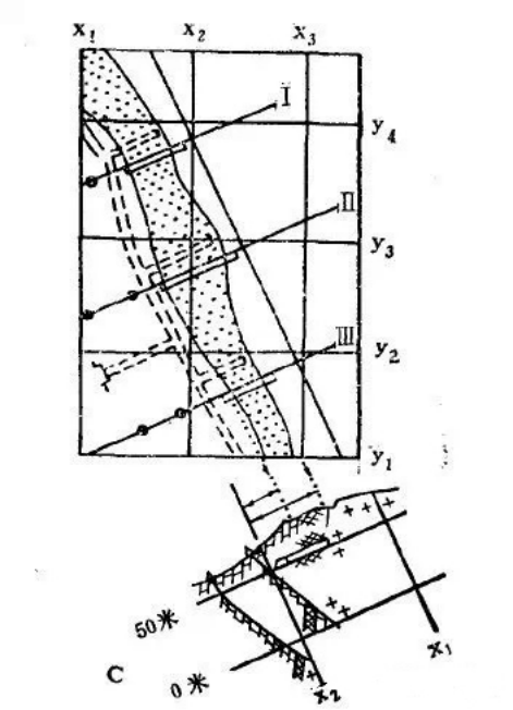
(Figure C)
On the basis of comprehensive analysis, research and inference, according to the relationship between their spatial positions, occurrence and geological laws, connecting structural lines such as rock boundaries between projects, ore body boundaries and faults (Figure D). In order to connect the geological boundaries. In the process of compiling each section, being attention to the comparison of its adjacent sections, and make the geological boundary conform to the law.

If it is used to calculate reserves, the boundaries of each ore type and reserve level should be drawn, meanwhile, the area number, area number and reserve level should be indicated.
Use the projection method to draw a plane sketch of the exploration line under the map, prepare an analysis result table according to different projects on one side, and finally write the map name, scale, and draw a legend and map label.
